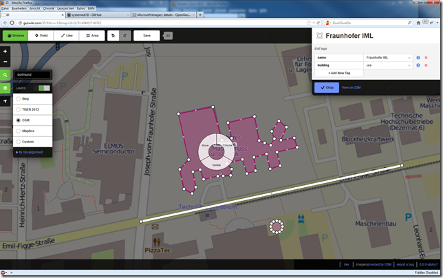
Es gibt einen neuen Web-basierten OSM-Editor. Der erste Eindruck ist sehr gut. eigene Zeichnungen auf Karten sind damit ein Kinderspiel.Gelöst ist die Sache mit D3.js und vielen anderen JavaScript Bibliotheken (s.u.)
Online Demo des iD-Editors: http://geowiki.com/iD/#id=w-1&map=18.21/51.49405/7.40723
Source https://github.com/systemed/iD
Auswahl von verschiedenen Basiskarten:

Einfachen Zeichnen von Kreis-ähnlichen Polygonen und Polygonen:


Benennung durch Name und Darstellung eines kreisähnlichen Polygons:
<script src='js/lib/lodash.js'></script>
<script src='js/lib/d3.v3.js'></script>
<script src='js/lib/sha.js'></script>
<script src='js/lib/ohauth.js'></script>
<script src='js/lib/jxon.js'></script>
<script src='js/lib/d3.typeahead.js'></script>
<script src='js/lib/d3.geo.tile.js'></script>
<script src='js/lib/d3.size.js'></script>
<script src='js/lib/d3.trigger.js'></script>
<script src='js/lib/d3.keybinding.js'></script>
<script src='js/lib/d3.tail.js'></script>
<script src='js/lib/d3-compat.js'></script>
<script src='js/lib/queue.js'></script>
<script src='js/lib/bootstrap-tooltip.js'></script>
<script src='js/lib/rtree.js'></script>
<script src='js/id/id.js'></script>
<script src='js/id/util.js'></script>
<script src='js/id/oauth.js'></script>
<script src='js/id/services/taginfo.js'></script>
<script src="js/id/geo.js"></script>
<script src="js/id/geo/extent.js"></script>
<script src='js/id/renderer/background.js'></script>
<script src='js/id/renderer/background_source.js'></script>
<script src='js/id/renderer/map.js'></script>
<script src='js/id/renderer/hash.js'></script>
<script src="js/id/svg.js"></script>
<script src="js/id/svg/areas.js"></script>
<script src="js/id/svg/lines.js"></script>
<script src="js/id/svg/member_classes.js"></script>
<script src="js/id/svg/midpoints.js"></script>
<script src="js/id/svg/multipolygons.js"></script>
<script src="js/id/svg/points.js"></script>
<script src="js/id/svg/surface.js"></script>
<script src="js/id/svg/tag_classes.js"></script>
<script src="js/id/svg/vertices.js"></script>
<script src="js/id/svg/labels.js"></script>
<script src="js/id/ui.js"></script>
<script src='js/id/ui/radial_menu.js'></script>
<script src='js/id/ui/inspector.js'></script>
<script src='js/id/ui/modal.js'></script>
<script src='js/id/ui/confirm.js'></script>
<script src='js/id/ui/commit.js'></script>
<script src='js/id/ui/success.js'></script>
<script src='js/id/ui/loading.js'></script>
<script src='js/id/ui/userpanel.js'></script>
<script src='js/id/ui/layerswitcher.js'></script>
<script src='js/id/ui/contributors.js'></script>
<script src='js/id/ui/geocoder.js'></script>
<script src='js/id/ui/geolocate.js'></script>
<script src='js/id/ui/notice.js'></script>
<script src='js/id/ui/flash.js'></script>
<script src='js/id/ui/save.js'></script>
<script src='js/id/ui/splash.js'></script>
<script src='js/id/ui/tag_reference.js'></script>
<script src='js/id/ui/key_reference.js'></script>
<script src='js/id/actions.js'></script>
<script src='js/id/actions/add_node.js'></script>
<script src='js/id/actions/add_way.js'></script>
<script src='js/id/actions/add_way_node.js'></script>
<script src='js/id/actions/change_entity_tags.js'></script>
<script src='js/id/actions/delete_node.js'></script>
<script src="js/id/actions/delete_way.js"></script>
<script src='js/id/actions/move_node.js'></script>
<script src='js/id/actions/move_way.js'></script>
<script src='js/id/actions/circular.js'></script>
<script src='js/id/actions/noop.js'></script>
<script src='js/id/actions/reverse_way.js'></script>
<script src='js/id/actions/split_way.js'></script>
<script src='js/id/actions/unjoin_node.js'></script>
<script src='js/id/behavior.js'></script>
<script src='js/id/behavior/add_way.js'></script>
<script src='js/id/behavior/drag.js'></script>
<script src='js/id/behavior/drag_midpoint.js'></script>
<script src='js/id/behavior/drag_node.js'></script>
<script src='js/id/behavior/draw.js'></script>
<script src='js/id/behavior/draw_way.js'></script>
<script src='js/id/behavior/hover.js'></script>
<script src='js/id/modes.js'></script>
<script src='js/id/modes/add_area.js'></script>
<script src='js/id/modes/add_point.js'></script>
<script src='js/id/modes/add_line.js'></script>
<script src='js/id/modes/browse.js'></script>
<script src='js/id/modes/draw_area.js'></script>
<script src='js/id/modes/draw_line.js'></script>
<script src='js/id/modes/move_way.js'></script>
<script src='js/id/modes/select.js'></script>
<script src='js/id/operations.js'></script>
<script src='js/id/operations/circular.js'></script>
<script src='js/id/operations/delete.js'></script>
<script src='js/id/operations/move.js'></script>
<script src='js/id/operations/reverse.js'></script>
<script src='js/id/operations/split.js'></script>
<script src='js/id/operations/unjoin.js'></script>
<script src='js/id/controller/controller.js'></script>
<script src='js/id/graph/entity.js'></script>
<script src='js/id/graph/graph.js'></script>
<script src='js/id/graph/history.js'></script>
<script src='js/id/graph/node.js'></script>
<script src='js/id/graph/relation.js'></script>
<script src='js/id/graph/way.js'></script>
<script src='js/id/graph/validate.js'></script>
<script src='js/id/connection.js'></script>


